![](/images/other/stat-length.png)
![Tour Wandern Le Malzieu-Forain - Lozere - Le Villard-Le-Malzieu-Ville Les trucs de Malzieu-Forain 24km 633m - Photo](https://media.geolcdn.com/t/1900/400/ext.pjpeg?maxdim=2&url=https%3A%2F%2Fstatic1.geolcdn.com%2Fsiteimages%2Fupload%2Ffiles%2F1553511878bg_sport_marche.png)
Lozere - Le Villard-Le-Malzieu-Ville Les trucs de Malzieu-Forain 24km 633m
RandoVal
Benutzer
![Länge](/images/other/stat-length.png)
Länge
24 km
![Maximale Höhe](https://static1.geolcdn.com/siteimages/upload/files/1508320355ic_sort_altitude_max_24dp.png)
Maximale Höhe
1353 m
![Positive Höhendifferenz](https://static1.geolcdn.com/siteimages/upload/files/1508320355ic_sort_den_pos_24dp.png)
Positive Höhendifferenz
725 m
![Km-Effort](/images/other/stat-length.png)
Km-Effort
34 km
![Min. Höhe](https://static1.geolcdn.com/siteimages/upload/files/1508320355ic_sort_altitude_min_24dp.png)
Min. Höhe
954 m
![Negative Höhendifferenz](https://static1.geolcdn.com/siteimages/upload/files/1508320355ic_sort_den_neg_24dp.png)
Negative Höhendifferenz
725 m
![Boucle](https://static1.geolcdn.com/siteimages/upload/files/16400158638029165_repeat_loop_refresh_sync_direction_icon.png)
Boucle
Ja
Erstellungsdatum :
2018-09-12 19:09:00.009
Letzte Änderung :
2018-09-12 19:09:00.018
![Wandern](https://static1.geolcdn.com/sitytour/trail-icons/101.png)
7h02
Schwierigkeit : Schwierig
![Scannen Sie diesen QR-Code, um die Tour in der SityTrail-Anwendung zu öffnen](https://capi.geolives.com/qq0zvz2zws4bq2lad0pu/sitytour/trails/648966/qr.png?size=200)
Kostenlosegpshiking-Anwendung
Über SityTrail
Tour Wandern von 24 km verfügbar auf Okzitanien, Lozère, Le Malzieu-Forain. Diese Tour wird von RandoVal vorgeschlagen.
Beschreibung
Randonnées entre Gévaudan et Margeride .
Départ du hameau Le-Villard-Le-Malzieu-Ville .
Beau sentier et belle forêt .
Sens horaire, version longue
Ort
Land:
France
Region :
Okzitanien
Abteilung/Provinz :
Lozère
Kommune :
Le Malzieu-Forain
Standort:
Unknown
Gehen Sie:(Dec)
Gehen Sie:(UTM)
527933 ; 4968384 (31T) N.
Kommentare
Touren in der Umgebung
![Tour Wandern Le Malzieu-Ville - Malzieu/Apcher - Photo](https://media.geolcdn.com/t/375/260/a747424a-8367-4c20-9f7f-a5139cd8aa78.jpg&format=jpg&maxdim=2)
![Wandern Wandern](https://static1.geolcdn.com/sitytour/trail-icons/101.png)
Malzieu/Apcher
Wandern
Einfach
(1)
Le Malzieu-Ville,
Okzitanien,
Lozère,
France
![](/images/other/stat-length.png)
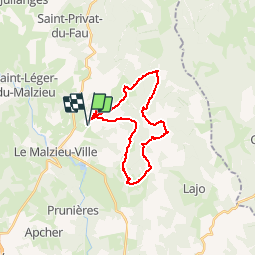
13,6 km | 17,7 km-effort
4h 4min
![](https://static1.geolcdn.com/siteimages/upload/files/16400158638029165_repeat_loop_refresh_sync_direction_icon.png)
Ja
![Tour Wandern Le Malzieu-Ville - LE MALZIEU - APCHER - Photo](https://media.geolcdn.com/t/375/260/cc36dc77-fa83-480d-88c5-be5f1e18e5a4.jpg&format=jpg&maxdim=2)
![Wandern Wandern](https://static1.geolcdn.com/sitytour/trail-icons/101.png)
LE MALZIEU - APCHER
Wandern
Medium
(1)
Le Malzieu-Ville,
Okzitanien,
Lozère,
France
![](/images/other/stat-length.png)
17 km | 23 km-effort
4h 21min
![](https://static1.geolcdn.com/siteimages/upload/files/16400158638029165_repeat_loop_refresh_sync_direction_icon.png)
Ja
![Tour Pferd Le Malzieu-Forain - MAJ 21 DRAILLE EN MARGERIDE 2eme partie vers Saugues - Photo](https://media.geolcdn.com/t/375/260/ext.jpg?maxdim=2&url=https%3A%2F%2Fstatic1.geolcdn.com%2Fsiteimages%2Fupload%2Ffiles%2F1524743154cheval.jpg)
![Pferd Pferd](https://static1.geolcdn.com/sitytour/trail-icons/300.png)
MAJ 21 DRAILLE EN MARGERIDE 2eme partie vers Saugues
Pferd
Sehr leicht
Le Malzieu-Forain,
Okzitanien,
Lozère,
France
![](/images/other/stat-length.png)
50 km | 64 km-effort
Unbekannt
![](https://static1.geolcdn.com/siteimages/upload/files/16400158638029165_repeat_loop_refresh_sync_direction_icon.png)
Ja
![Tour Reiten Le Malzieu-Forain - Etoile Première boucle Pré hiver 25 km - Photo](https://media.geolcdn.com/t/375/260/ext.jpg?maxdim=2&url=https%3A%2F%2Fstatic1.geolcdn.com%2Fsiteimages%2Fupload%2Ffiles%2F1524743154cheval.jpg)
![Reiten Reiten](https://static1.geolcdn.com/sitytour/trail-icons/301.png)
Etoile Première boucle Pré hiver 25 km
Reiten
Einfach
Le Malzieu-Forain,
Okzitanien,
Lozère,
France
![](/images/other/stat-length.png)
25 km | 36 km-effort
1h 4min
![](https://static1.geolcdn.com/siteimages/upload/files/16400158638029165_repeat_loop_refresh_sync_direction_icon.png)
Nein
![Tour Wandern Le Malzieu-Ville - tour du lac de la graviére de la Chazette - Photo](https://media.geolcdn.com/t/375/260/ext.jpg?maxdim=2&url=https%3A%2F%2Fstatic1.geolcdn.com%2Fsiteimages%2Fupload%2Ffiles%2F1553511878bg_sport_marche.png)
![Wandern Wandern](https://static1.geolcdn.com/sitytour/trail-icons/101.png)
tour du lac de la graviére de la Chazette
Wandern
Einfach
Le Malzieu-Ville,
Okzitanien,
Lozère,
France
![](/images/other/stat-length.png)
4,9 km | 5,2 km-effort
1h 9min
![](https://static1.geolcdn.com/siteimages/upload/files/16400158638029165_repeat_loop_refresh_sync_direction_icon.png)
Ja
![Tour Wandern Le Malzieu-Forain - Lozere - Le Villard-Le-Malzieu-Ville Les trucs de Malzieu-Forain 18km 477m - Photo](https://media.geolcdn.com/t/375/260/ext.jpg?maxdim=2&url=https%3A%2F%2Fstatic1.geolcdn.com%2Fsiteimages%2Fupload%2Ffiles%2F1553511878bg_sport_marche.png)
![Wandern Wandern](https://static1.geolcdn.com/sitytour/trail-icons/101.png)
Lozere - Le Villard-Le-Malzieu-Ville Les trucs de Malzieu-Forain 18km 477m
Wandern
Medium
Le Malzieu-Forain,
Okzitanien,
Lozère,
France
![](/images/other/stat-length.png)
18,2 km | 26 km-effort
5h 22min
![](https://static1.geolcdn.com/siteimages/upload/files/16400158638029165_repeat_loop_refresh_sync_direction_icon.png)
Ja
![Tour Wandern Le Malzieu-Forain - Lozere - Le Villard-Le-Malzieu-Ville Les trucs de Malzieu-Forain 14km 410m - Photo](https://media.geolcdn.com/t/375/260/ext.jpg?maxdim=2&url=https%3A%2F%2Fstatic1.geolcdn.com%2Fsiteimages%2Fupload%2Ffiles%2F1553511878bg_sport_marche.png)
![Wandern Wandern](https://static1.geolcdn.com/sitytour/trail-icons/101.png)
Lozere - Le Villard-Le-Malzieu-Ville Les trucs de Malzieu-Forain 14km 410m
Wandern
Einfach
Le Malzieu-Forain,
Okzitanien,
Lozère,
France
![](/images/other/stat-length.png)
13,6 km | 19,9 km-effort
4h 8min
![](https://static1.geolcdn.com/siteimages/upload/files/16400158638029165_repeat_loop_refresh_sync_direction_icon.png)
Ja
![Tour Wandern Le Malzieu-Forain - Saint Pierre le Vieux - Photo](https://media.geolcdn.com/t/375/260/ext.jpg?maxdim=2&url=https%3A%2F%2Fstatic1.geolcdn.com%2Fsiteimages%2Fupload%2Ffiles%2F1553511878bg_sport_marche.png)
![Wandern Wandern](https://static1.geolcdn.com/sitytour/trail-icons/101.png)
Saint Pierre le Vieux
Wandern
Einfach
Le Malzieu-Forain,
Okzitanien,
Lozère,
France
![](/images/other/stat-length.png)
6,3 km | 8,4 km-effort
1h 40min
![](https://static1.geolcdn.com/siteimages/upload/files/16400158638029165_repeat_loop_refresh_sync_direction_icon.png)
Ja
![Tour Wandern Le Malzieu-Ville - Molières - Photo](https://media.geolcdn.com/t/375/260/ext.jpg?maxdim=2&url=https%3A%2F%2Fstatic1.geolcdn.com%2Fsiteimages%2Fupload%2Ffiles%2F1553511878bg_sport_marche.png)
![Wandern Wandern](https://static1.geolcdn.com/sitytour/trail-icons/101.png)
Molières
Wandern
Einfach
Le Malzieu-Ville,
Okzitanien,
Lozère,
France
![](/images/other/stat-length.png)
4,3 km | 6 km-effort
1h 0min
![](https://static1.geolcdn.com/siteimages/upload/files/16400158638029165_repeat_loop_refresh_sync_direction_icon.png)
Ja